今日上海
比利时学者的寻找上海“中点”之旅 - 2017年02月17日
Journey to the centerpoints of Shanghai

THE Greek mathematician Archimedes once said that give him a place to stand and he would move the world.
It was a demonstration of the theory of the lever some 1,700 years ago and it depends on finding the right fulcrum and exerting an appropriate amount of force to move something.
Today, the Belgian architect and researcher Cédric Van Parys, 27, could — theoretically, at least — jack up Shanghai based on the ancient theory.
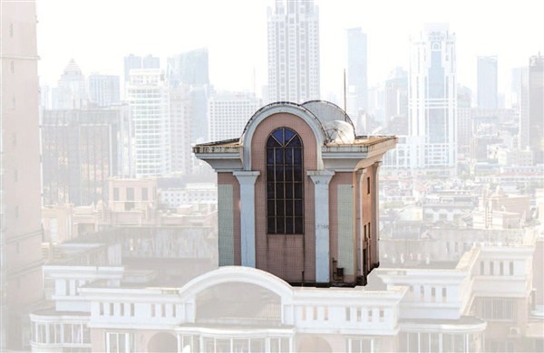
Van Parys spent about 10 months last year traveling to the corners of Shanghai, seeking architectural landmarks that gloriously represent Shanghai’s breakneck progress since the early 1990s.
Researching Shanghai’s development and architectural history made Van Parys aware of the “district boundary adjustments,” he says. Because of these adjustments, local districts keep merging and expanding.
“I’m using the geographic centerpoints of these districts to show the city’s progress,” Van Parys says. “I believe the mysterious monuments on top of the skyscrapers in these centerpoints truly represent Shanghai’s past, present and future.”
About four years ago, Van Parys first came to the city with an architectural project in mind. What fascinated him most were the different roofs of high buildings along the city’s skyline. “When I looked up at the sky, I always wanted to figure out why these strange structures were on top of those high-rises,” he says.
The architect learned that in Chinese culture, there always has to be something on top of a building.
“Shanghai is like a melting pot,” says Van Parys. “It’s the only city where so many different cultures have passed, giving birth to different architectural styles. The rooftops could be temples, modern sculptures or very futuristic structures. That intrigued me.”
Four years later in 2016, he returned to Shanghai with a centerpiece project he called “Monuments for Progress.”
For a whole summer, the Belgian rode on his scooter with a camera, crisscrossing the city, looking for these geographic centerpoints. He climbed to the top of numerous skyscrapers, where he photographed and filmed the crowns of each architectural landmark.
Then he returned to his work studio and reproduced the urban centerpieces into a series of associated prototypes through a combination of 3D printing and handcrafted work.
He used an analogue method to define the geographic center of each district.
It relied on the force of gravity, because a district is a flat, irregular shape. He suspended the shape of the district from two locations, with plumb lines dropped from the suspension points. The intersection of the two lines is the gravitational center. The third line was to verify the accuracy of the methodology.
After the centers were logged, Van Parys set off on his journey of monuments.
“Shanghai’s rapid expansion into an extreme dense landscape of high-rises made it possible to adopt such a pragmatic system,” he says. “Wherever I went, there was almost always a skyscraper.”
He climbed up to nearby buildings to get closer to the centers of gravity and documented the roofs. Luckily for him, most rooftops were accessible.
“I just walked in, probably because the security guys didn’t know how to talk to me,” he says. “Most were residential buildings and people living there didn’t really know each other.”
When reaching the top, the architect took photos of rooftop monuments from different perspectives.
“When I could not get up to the top, I had to find an open window to take pictures,” he recalls, adding that he’s climbed more than 300 buildings.
A few times when Van Parys drove to suburban districts, the geographic centerpoints happened to be farmland.
“No skyscraper within a radius of 500 meters from the geographic centerpoint means no sign of progress yet, and subsequently no ‘monuments for progress’,” he says. “But if you go back in five years, things might be different.”
When the boundaries of districts are adjusted, the location of the geographic centerpoints naturally changes as well.
Last year, Jing’an and Zhabei districts were merged to form the new Jing’an District. The old Jing’an geographic center was a building located at 418 Changde Road, while the old Zhabei geographic center was a building at 524 Lingshi Road. After the merger, the geographic center of the new Jing’an District has shifted north to 757 Luochuan Road M.
“Each time a district expands or is merged with another one, a new geographic center will be generated,” he says. “Subsequently, a new ‘Monument for Progress’ will be highlighted.”
He adds, “Each district has its own specific function — its identity,” he says. “Huangpu is more business-oriented, and Jing’an is a shopping hub, while Xuhui is largely residential and Yangpu is a harbor district.”
In his studio, Van Parys turned 2D photos into 3D models of each of these “monuments for progress.” The scaled structures were placed into a series of invented landscapes.
He chose two colors — dark blue for landscape and gold for rooftops.
“The dark blue was related to that moment in the evening before the Shanghai sky gets really dark, and gold is a color that signifies something valuable and royal, which is much beloved by the Chinese,” explains the Belgian.
The architect let his imagination roam for the landscapes. Former Luwan District’s monument, to Van Parys, looked like a station on the North Pole, so he designed a landscape of icebergs and glaciers. The geographical center of new Huangpu District looked like a Greek temple, so the architect put it on a gently sloping hill.
So far Van Parys has done the first seven models. He will complete the project — encompassing 25 models — in Europe. It will also include the city’s geographic centerpoint, located at 6555 Humin Road in Minhang District, which happens to be on top of the China Construction Bank.
“The city keeps changing,” Van Parys says. “It’s a progression that never stops.”
For more information, visit http://monumentsforprogress.altervista.org, or check Van Parys’ personal website at http://www.cedricvanparys.com.
